
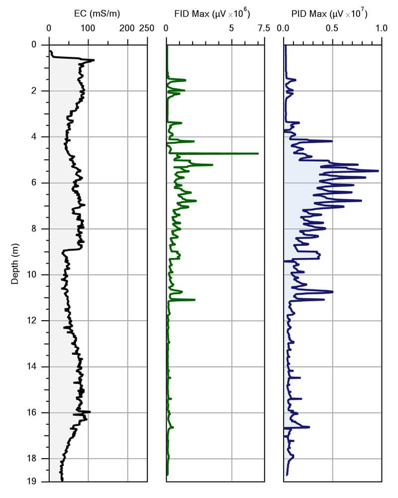
MIP log from the site in northern Ontario showing (l to r) Electrical Conductivity, MIP-PID, and MIP-FID. The log indicates the highest levels of contamination at depths from 11 to 37 ft. (3 to 11 m) bgs.
Contributed by Patrick O’Neill, MASc
Project Manager for Vertex Environmental Inc.
Cambridge, Ontario Canada
Vertex Environmental was retained to complete a large in-situ chemical oxidation injection remediation project by the provincial government in northern Ontario, Canada. Due to large data gaps that existed in the soil and groundwater analytical data, a direct imaging tool, the Membrane Interface Probe (MIP), was deployed by Vertex, located in Cambridge, Ontario, to fully delineate the extent of petroleum hydrocarbon (PHC) impacts.
An historic leak from an underground storage tank released over 5,000 gal (19,000 L) of gasoline directly into the subsurface over a five-year period. Extensive borehole drilling and groundwater monitoring well installation was completed soon after the release was discovered to delineate the on-site plume. A downgradient area of high concentrations (>240,000 ug/L total PHCs) was discovered with groundwater impacts extending up to 85 feet (26 meters) below ground surface. However many data gaps were present for the size of remediation that was required for the site. An innovative and cost-efficient approach to delineation, both vertically and horizontally, was required to close these data gaps.
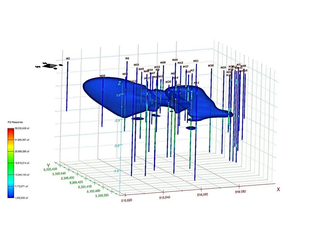
Instead of drilling additional boreholes and installing more groundwater monitoring wells for sampling and laboratory analysis, Vertex mobilized the MIP direct imaging tools to the site for rapid in-situ delineation. The MIP quickly and efficiently delineated the extents of the dissolved-phase PHC impacts where data gaps existed on-site, both vertically and horizontally across the impacted area. With the MIP data it was determined that the majority of the PHC impacts were situated between 10 feet (3 meters) and 36 feet (11 meters) below ground surface, with minimal impacts present at greater depths. The MIP data were then imported into 3D visualization software to provide added clarity of the impacted zones. Without the comprehensive data from the MIP investigation, many impacted zones and depths would likely have been missed.
The subsequent remediation program was then optimized using the results from the MIP investigation for more efficient placement of chemical oxidants to specifically target the impacted zones. As such, these efforts resulted in better treatment of the PHC impacts at the site.
Contact Us
1835 Wall Street
Salina, Kansas 67401
Phone: (785) 825-1842
Photo Gallery
MIP log from the site in northern Ontario showing (l to r) Electrical Conductivity, MIP-PID, and MIP-FID. The log indicates the highest levels of contamination at depths from 11 to 37 ft. (3 to 11 m) bgs.
MIP data collected onsite quickly delineated the extents of the dissolved-phase PHC impacts (between 10 and 36 feet (3 and 11 meters). The data was imported into 3D visualization software to provide added clarity of the impacted zones.
Related Videos
ID: 6608
ID: 6082
ID: 5344
ID: 1975
ID: 1892
ID: 1995
ID: 1979
ID: 1977