
High Resolution Site Characterization (HRSC) logging tool provides accurate, real-time data to craft effective remediation strategy.
Progressing up the ladder from consultant to senior project manager, David Heicher found himself spending more time managing people and budgets and less time in the field.
“I’d been in the business 12 years and had a young family so felt stuck,” Heicher said. “I had my resume online and got a phone call from a guy who was looking for people to train on Membrane Interface Probe (MIP). I looked into the technology and thought ‘if this works, this is the wave of the future and where assessment needs to go’.”
Heicher caught that wave spending 300 days a year traveling the United States conducting High Resolution Site Characterization (HRSC). When a drilling company in Australia who had purchased MIP discovered they needed an experienced operator, he and his family rode the wave across the ocean.
“I was the only one who knew how to run the system and having been on the consulting side, I knew what clients needed,” Heicher said. “I spent two years doing projects and moving into business development, teaching people about the technology and generating awareness across Australia.”
When the family decided to return to the U.S., he seized the chance to launch a Southeast presence for a company doing HRSC work. As the company grew he trained operators and returned to business development. Along the way he considered starting his own company.
"January 2022 I started GEOIMAGING SYSTEMS as a single owner/operator company,” Heicher said. “I had a good 2022, but in 2023 I’ve already done half of what I accomplished all 2022.”
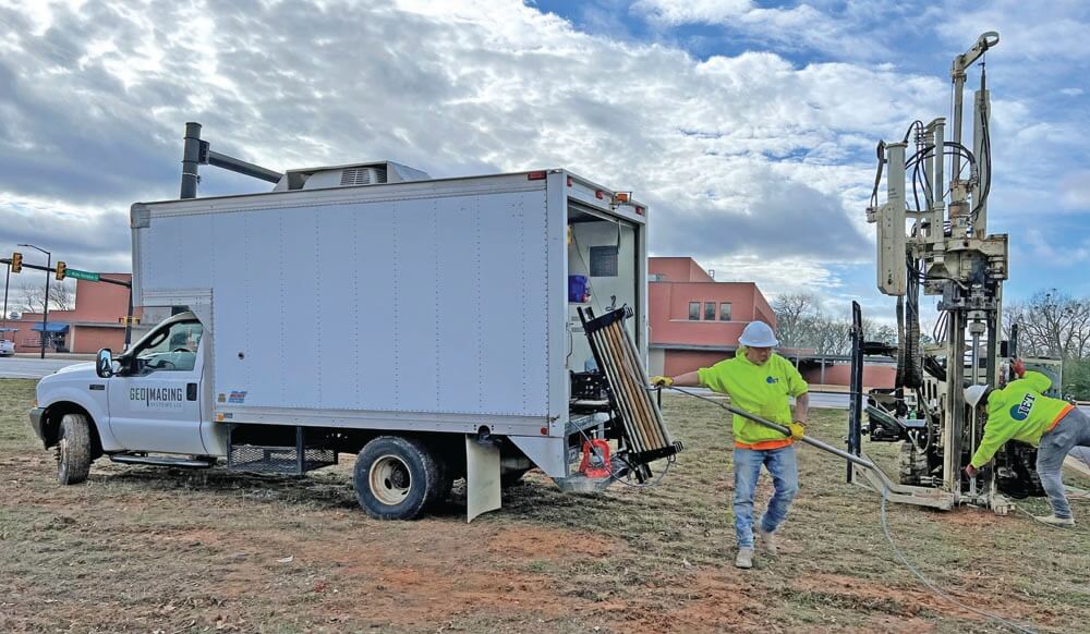
His extensive experience with HRSC has put him in some interesting situations. On one project he found himself surrounded by cattle in a cow pasture, which had formerly been used as a landfill for an HVAC component production facility. Another project had him navigating dense woods and hilly terrain on a UTV to conduct an MIP investigation of a trichloroethylene (TCE) drum burial site with a creek nearby exhibiting cVOC impacts. For his first GeoImaging project he wheeled a dolly rig and 3-foot tooling into the lower-level of a multi-story apartment building. He sat in the kitchen floor of the vacated apartments in search of an unidentified water source suspected of causing foundation issues and instability, studying the hydrogeology and lithology in efforts to save the sinking building.
For his current work he uses Geoprobe® Direct Image® logging tools — Membrane Interface Hydraulic Profiling Tool (MIHPT), Optical Image Profiler Hydraulic Profiling Tool (OIHPT) and Hydraulic Profiling Tool (HPT).
“I’m a big proponent of Geoprobe®, I know the strength of the tooling and technology,” Heicher said. "Over almost 20 years, I have 'beta tested' many iterations (small and large) of Geoprobe® Direct Image® technologies, and I’ve been very impressed with the dedication the Direct Image® team has shown in making these tools more robust, accurate, and user-friendly."
Not surprisingly given his extensive background, he’s also a big proponent of HRSC for its ability to provide so much more data.
“Conventional monitoring wells are for monitoring, not for site characterization. They’re holes in the ground that lie to you,” Heicher said. “With MIP you get 20 readings per foot. Conventional sampling you might take five soil samples per boring, then set a 10- to 20-foot monitoring well to collect groundwater, which then provides one data point.”
Data combined with years of experience provide proof of contamination's inconsistencies.
“Concentration of contamination isn’t stable throughout a whole screen level. There are lenses and layers,” Heicher said. “Conventional methods are like a black and white TV with an antenna — everything is fuzzy. You don’t get dots per inch and clarity HRSC can provide.”
Through the years he’s identified two consistent advantages of completing HRSC logging tool assessment.
Logging Tool Accuracy Facilitates Effective Remediation
Heicher finds that on 80 to 90 percent of sites, the first Direct Image® logging tool boring changes the entire site conceptual model.
“That’s the power of the tool. Direct Image® tools just make sense to use so that a High Resolution Conceptual Site Model can be developed quickly, effectively, and accurately,” Heicher said. “Most of the time monitoring wells haven’t been placed at the right depth or location. Generally, most of the contamination is below the well.”
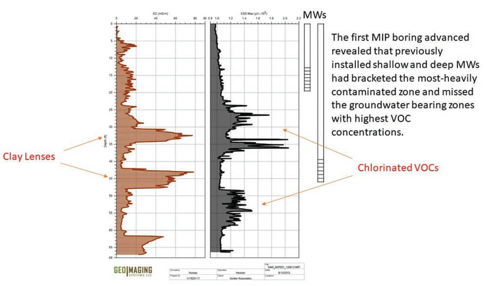
On a World War II Air Force base in Australia, monitoring wells had been installed where tanks were once placed on ramps to rinse out engine compartments. Some of the screens stopped at 20 feet. A few were deeper at 50 feet. The deeper ones continued exhibiting contamination despite remediation.
“On the first boring, we discovered contamination at 25- to 27-feet below ground surface and 47 to 60 feet. The dozens of monitoring wells were installed at insufficient depths where the worst of the groundwater contamination existed,” Heicher said. “HRSC crunches time scale down and moves to more effective remediation, faster.”
Real-time Data from Logging Tool Drives Dynamic Work Plan
Utilizing Direct Image® logging tools enables decisions directly influencing the investigation to be made in the field. In Heicher’s experience this facilitates obtaining the most pertinent data required to meet the project objectives.
For example, conventional investigations had identified contamination at the top of a confining clay layer at 20 feet on a TCE site near the coast of South Carolina. Despite injection work, elevated concentrations of TCE persisted in their monitoring wells. Heicher spent a day and a half conducting MIP logs, discovering lenses and layers.
“We didn’t detect any contamination in the clay layer, meaning the previous injections had worked, but found pockets elsewhere,” Heicher said.
Using the real-time data, the remediation team was suited up to immediately perform injection into the zones where MIP identified contamination.
“Assessment identifies exactly where to focus efforts and reduces costs and time for actual remediation,” Heicher said. "Decisions can be made in the field to help drive the field investigation so horizontal and vertical delineation of subsurface contamination can be achieved in one mobilization."
Contact Us
1835 Wall Street
Salina, Kansas 67401
Phone: (785) 825-1842
Photo Gallery
High Resolution Site Characterization (HRSC) logging tool provides accurate, real-time data to craft effective remediation strategy.
MIP log from World War II Air Force base in Australia.
Related Articles
Related Videos
ID: 6608